


Mitchell Precinct, Scotts Bluff County, Nebraska
About
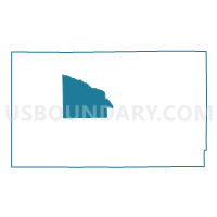
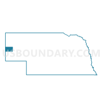
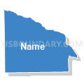
Outline

Summary
| Unique Area Identifier | 613906 |
| Name | Mitchell Precinct |
| County | Scotts Bluff County |
| State | Nebraska |
| Area (square miles) | 49.86 |
| Land Area (square miles) | 49.75 |
| Water Area (square miles) | 0.11 |
| % of Land Area | 99.78 |
| % of Water Area | 0.22 |
| Latitude of the Internal Point | 41.87358130 |
| Longtitude of the Internal Point | -103.80092270 |
Maps

Graphs
Select a template below for downloading or customizing gragh for Mitchell Precinct, Scotts Bluff County, Nebraska


Neighbors
Neighoring Voting District (by Name) Neighboring Voting District on the Map
- Fanning Precinct, Scotts Bluff County, NE
- Ford A & B Precinct, Scotts Bluff County, NE
- Gering Precinct, Scotts Bluff County, NE
- Kiowa-Lyman Precinct, Scotts Bluff County, NE
- Roubadeau Precinct, Scotts Bluff County, NE
- Scottsbluff 5 Precinct, Scotts Bluff County, NE
- West Winter Creek Precinct, Scotts Bluff County, NE
Top 10 Neighboring County Subdivision (by Population) Neighboring County Subdivision on the Map
- Scottsbluff city, Scotts Bluff County, NE (15,039)
- Gering precinct, Scotts Bluff County, NE (2,208)
- Ford precinct, Scotts Bluff County, NE (1,508)
- West Winters Creek precinct, Scotts Bluff County, NE (1,443)
- Fanning precinct, Scotts Bluff County, NE (1,042)
- Kiowa precinct, Scotts Bluff County, NE (818)
- Mitchell precinct, Scotts Bluff County, NE (493)
- Roubadeau precinct, Scotts Bluff County, NE (140)
Top 10 Neighboring Place (by Population) Neighboring Place on the Map
Top 10 Neighboring Unified School District (by Population) Neighboring Unified School District on the Map
- Scottsbluff Public Schools, NE (19,048)
- Gering Public Schools, NE (11,327)
- Mitchell Public Schools, NE (3,250)
- Morrill Public Schools, NE (2,510)
Top 10 Neighboring State Legislative District Upper Chamber (by Population) Neighboring State Legislative District Upper Chamber on the Map
Top 10 Neighboring 111th Congressional District (by Population) Neighboring 111th Congressional District on the Map
Top 10 Neighboring Census Tract (by Population) Neighboring Census Tract on the Map
- Census Tract 9539, Scotts Bluff County, NE (5,479)
- Census Tract 9533, Scotts Bluff County, NE (3,334)
- Census Tract 9530, Scotts Bluff County, NE (3,176)
- Census Tract 9536, Scotts Bluff County, NE (3,070)
- Census Tract 9531, Scotts Bluff County, NE (2,318)
- Census Tract 9532, Scotts Bluff County, NE (1,524)